


Gaillemarde-Argenteuil

BruChan
User
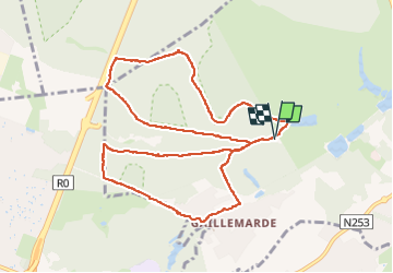

Length
10.4 km

Max alt
144 m

Uphill gradient
200 m
Km-Effort
13.1 km

Min alt
68 m

Downhill gradient
200 m
Boucle
Yes
Creation date :
2024-09-20 12:33:02.654
Updated on :
2024-09-20 14:44:12.599
2h00
Difficulty : Medium

FREE GPS app for hiking
 SityTrail
IGN / Geographical institutes
SityTrail Plus
The world is yours!
About
Trail Walking of 10.4 km to be discovered at Wallonia, Walloon Brabant, La Hulpe. This trail is proposed by BruChan.
Positioning
Country:
Belgium
Region :
Wallonia
Department/Province :
Walloon Brabant
Municipality :
La Hulpe
Location:
Unknown
Start:(Dec)
Start:(UTM)
602391 ; 5620901 (31U) N.
Comments